Ala Archa National Park is a popular day or 2 day hiking trip from Bishkek. With just a short ride out of the city you’ll gain access to pristine snow capped mountains, pine forests, glaciers and alpine rivers. I did a day hike in Ala Archa National Park with 2 roommates from the hostel I stayed in. Here’s all about my visit to this beautiful park!
For detailed information on planning a trip to Ala Archa National Park (1 or 2 days, getting there, distances, with/ without guide) scroll till the end.
Day hike to waterfall and back
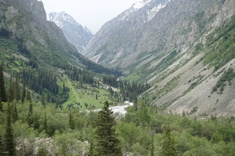
As my roommates in the hostel were interested in visiting Ala Archa National Park on the same day, we decided to get private transport, organized by the hostel, to the park (2450 som, all in). With the snow-capped mountain range already visible from Bishkek, it did not take long for us to be deep in the mountains. A short ride later we were at the start of the trail. We confirmed with our driver that we would be back in 5 hours, and left to explore the park on our own. Started off looking like a fine summer day (was around mid June) but as locals had cautioned, it is possible to experience all four seasons in a day in the mountains.

The more popular of these 2 trail below is the one to Ak Sai Waterfall, with an option to extend the trek to the glaciers if you’re fast enough to do it in a day, or if you’re prepared to camp the night at the end of the trail, at the Ratsek Hut.

We took the Ak Sai Waterfall Trail, turning left and turning left to the next valley. At times the trail wasn’t very clear but if you keep to the left and looked for the most obvious trail you should be on your way.
Alplager Hut to Broken Heart
From deep within the pine forests the trail rose quickly above the tree line and soon turned left to the next valley. Despite the clear blue skies slipping away the scenery was still amazing, pine trees lining glacier fed streams from snow-capped mountain peaks.
Continuing on the most obvious paths that went towards the left, on to the next valley perpendicular to the one we started in, we arrived at the first landmark, the Broken Heart. This large rock out of nowhere was perfectly split down the middle. There is a more famous ‘Broken Heart’ at Jeti Oguz, near Karakol, which I was to see in a few days, but this was not small too.

Broken Heart to Tepshi Plato
Not long after, a big flat open field, the Tepshi Plato (Plateau?) stretched along the side of the mountain. After that earlier uphill climb this was a much more enjoyable walk.
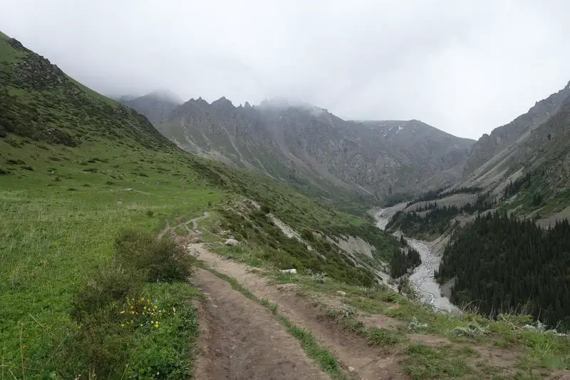

The rocky stream crossing
After the Tepshi Plato the trail descends down a steep rocky valley to a rushing stream. No worries though, there is no need to get wet crossing it. If the flow is too heavy just follow it upstream, looking out for cairns, or stacked rocks, that point out where others have crossed before. Pick a suitable path and step over the jutting rocks to cross the stream. We stopped here for some snacks, before another steep ascent on rocky ground to get back to the dirt trail.


The final stretch towards Ak Sai Waterfall in Ala Archa National Park
The mountains came closer and closer, their jagged peaks clearer and clearer.

Ak Sai Waterfall can already be seen early in the trail, but coming up close was still a special moment. Snow covered mountains lay just beyond the waterfall.

At the information board for Ak Sai Waterfall, the trail branches out. The left path leads right to the foot of the waterfall, which the right path continues the the glaciers at Ratsek Hut (Razeka Station).
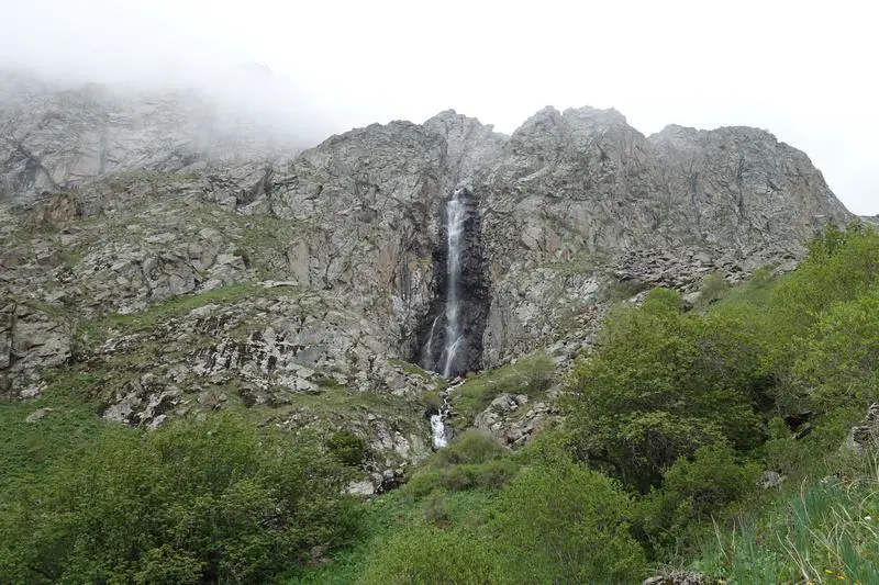
At the waterfall we came across a large family with lots of kids and they seemed to be managing well so I suppose this trail is pretty family friendly. What wasn’t so friendly though, was the weather. With rain pelting through the afternoon it got very cold by the time we reached the waterfall, at 2,665m above sea level.
The way back
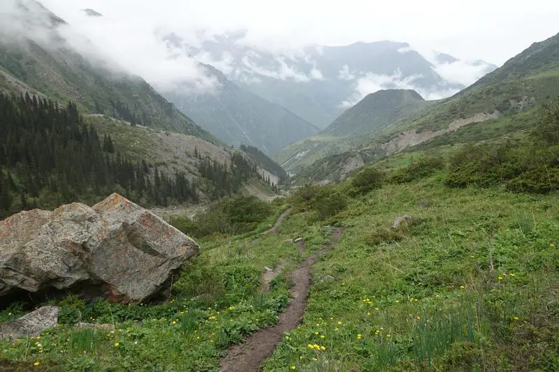
As we did not prepare to spend a night at the mountains, and were about halfway through our time allowance with our driver waiting at the trail head, we started on our way back. I didn’t realize how foggy it had gotten till I turned back and saw much of the mountains hidden by the clouds/fog.

Fortunately, as we descended the fog cleared up. Taking the walk at a comfortable pace, with some time for snacking and resting, we arrived back at the car park/ trail head just under 5 hours from when we started. Including some time spent looking for a lost team member along the way. Long story short, keep to the most obvious trail, and keep left for as long as you can’t see the waterfall in the distance. Once you can see the waterfall just head towards it all the way. On the way back it’ll be quite difficult to get lost. It is not difficult to get through the trail without a guide, but on the other hand it is still possible to get lost.
At the car park, our cheerful driver was waiting, and not long after, we were back at the hostel. Day 2 of Kyrgyzstan done, a lovely teaser of the mountains for my longer hike waiting at Karakol!
Ala Archa National Park – Planning your trip
1 day or 2 days in Ala Archa National Park?
With a day hike you should comfortably be able to reach Ak Sai Waterfall and get back, the amazing views of pine forest, mountain rivers and snow capped peaks as seen above. With 2 days you will be able to cover the waterfall trail and reach Ratsek Hut (Razeka Station), catch the glaciers and spend a night there before returning back the same way. Or if you’re fast and start early you can reach Ratsek Hut (Razeka Station) after the waterfall and make it back to the entrance in a day. Keep in mind that if you’re hiring private transport and asking the driver to wait they generally wait for around 4-5 hours. By marshrutka the last bus leaves the main gate at 5.00/5.30pm (17:00/17:30).
Getting from Bishkek to Ala Archa National Park
By public transport (marshrutka)
Marshrutka #265 from Osh Bazaar (Beyshenaliyeva Street) heads towards Ala Archa National Park. Some of these trips end at Kashka Suu village, 10km from the park entrance, and the occasional one reaches the park, and you’ll need to check with the driver to find out. If it ends at Kashka Suu you may be able to negotiate with the driver for an additional fee to get you to the park. From the park entrance it is another 12km to the start of the trail. According to Megan Starr the marshrutkas at 08.00am and 10.50am may be able to get you to the park entrance. It should also be possible to hitchhike the rest of the way to the start of the trail. There is an entrance fee of 80 som per person too. Marshrutkas returning from the park gate to Bishkek leave about every few hours till 5pm/ 5.30pm (17:00/17:30).
By private transport/ taxi (the option I took)
Our hostel (Apple Hostel Bishkek) arranged transport for us, which saved a fair bit of trouble with the language barrier in mind. It costed us 2450 som (36 USD) for the whole car including entrance fees and 5 hours of waiting time. Relatively much more expensive than public transport, but without the hassle of potentially having to hike/ hitchhike the stretch between the bus stop and the park entrance. You should be able to arrange private transport either through your hostel or by catching a taxi service at Osh Bazaar. Might be able to get a much better deal than what I got, but it shouldn’t cost much more.
With the Trekking Union of Kyrgyzstan
There is another option to participate in a tour with the Trekking Union of Kyrgyzstan. Prices start from 450 som according to their site. I’m not able to find out more but it seems to also be a recommended option if you don’t mind doing the hike with a larger group.
Hiking distances in Ala Archa National Park (Ak Sai Waterfall Trail)
According to information boards in the park, here are the altitudes, distances and approximate time required between the various checkpoints of the hike from the start of the trail at Alplager Hut to the Ratsek Hut (Razeka Station).
- Alplager Hut (start of trail, 2200m) to Broken Heart (2377m): 1.5km, 1 hour
- Broken Heart to Tepshi Plateau (2458m): 0.3km, 20 min
- Tepshi Plateau to Ak Sai Waterfall (2665m): 2.2km, 1 hour
- Waterfall to Razeka Station (Ratsek Hut, 3300m): 2.4km, 2 hour 30 min
Total distance and time:
- To Ak Sai Waterfall: 4km, 2 hour 20 min (8km, 4 hour 40 min for round trip)
- To Ratsek Hut (Razeka Station): 6.4km, 4 hour 50 min (12.8km, 9 hour 30 min for round trip)
Note that the waterfall itself is slightly off the trail to Ratsek Hut, about 10 mins from the main trail. You’ll be able to see the waterfall from early on the trail after the Broken Heart.
Do I need a guide to hike Ala Archa National Park?
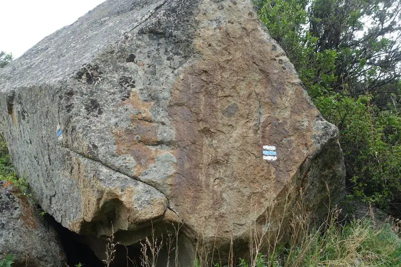
If you’re keeping to the main trail there isn’t a need to get a guide, although one of our hiking party got lost halfway when we we momentarily separated. Just follow the most obvious trail and look out for paint marks, 2 white stripes separated by a blue stripe, to know you’re on track. If that sounds challenging, you may want to get a guide or follow a tour, such as with the Trekking Union of Kyrgyzstan.
That’s all I have from Ala Archa National Park! Up next, the highlight of my trip to Kyrgyzstan, and the reason I did this trip – a 5 day hike in the Tian Shan Mountains, near to Karakol. Come back soon for more on that epic solo hike!
")


