First half of my first bushwalking experience, on the Overland Track in Tasmania, in May 2019. After seeing it feature on so many top hikes lists, I had to see what the Overland Track was all about. This was probably the tougher half, compounded by miserable weather on the first 2 days. Still, the Tasmanian wilderness is a sight to behold in any weather, and what better way to experience it than a few days living in the middle of it all?
How this happened …
Unlike my last few hiking trips this was a relatively last minute decision. I was getting restless months after Yading and couldn’t wait till summer begins in the Northern Hemisphere, where most of my to-do hikes are. One last chance in May to squeeze in a Southern Hemisphere hike before winter begins. This was how my first ever visit to Australia started. I initially planned to do it alone, but as it was not advisable and since a good friend was interested in trying long distance hiking, this also became my first time doing a long distance hike with company. Taking transport and weather into account, May isn’t the best time to hit the Overland Track, but that’s how it all began.
To jump to the second half of my Overland Track journey (day 4-6), click here.
To the start of the trail
After a day of flying, we got up early to to catch our pre-booked transport with Overland Track Transport from Launceston to Ronny Creek. Weather on the way was wet and gloomy, as forecasted, and we were hoping for better weather at the start. That didn’t happen when we arrived at Ronny Creek around 10.30am. Out came rain gear as we buckled up, took the obligatory pictures with the sign at the start of the walk, and started on our way into the Tasmanian wilderness.

Overland Track Day 1: Ronny Creek to Waterfall Valley Hut
Ronny Creek to Crater Lake
It was an easy warm up at the start with duckboard over buttongrass plains for the first half hour.

After the mad rush from home to the airport to a different continent then to the start of the walk it was finally time to take in nature and slow things down a little.

Then came a teaser of the forests, still paved. Within steps the landscape totally changed, from wide open buttongrass plains to moss covered forests. Also in this first forest is the first waterfall along the way, with many to follow.


Beyond Crater Falls it was time for a short climb up some stairs, and out of the forests to open terrain . Just a slight rise in altitude, but a totally different landscape again.

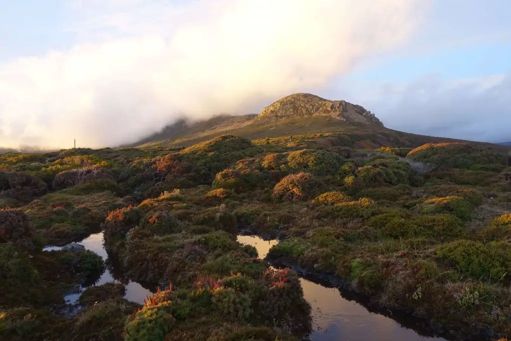
Weaving around the shrubs, we soon arrived at Crater Lake, surrounded by mountains with peaks in the clouds. The track goes round the left side of Crater Lake, and halfway round is where the climbs start to get serious.

Crater Lake to Marion’s Lookout
Soon we were some height from the lake surface. Looking down, the trees extended all the way to the edge of the lake. Before us on the track, the foliage was thinning as we started towards Marion’s Lookout.


Nearing the far end of Crater Lake, the ascent to Marion’s Lookout began. Gradually at first, but very quickly, very steeply.

The gravel path gets gradually steeper until it reaches the rockface. This is the steepest part of the Overland Track (not considering side trips up the mountain summits). Where the gravel path ended wooden planks are nailed vertically to the ground to form steps against what would otherwise be an impossible path.

At the very last part of the climb, even the planks get difficult and you’ll need your hands free to pull against the railings to get up. You’d not want to get too close to the person in front in case they fall backwards.

At the top, we caught our breaths and the views. Over the other side of the mountains is Dove Lake. The track cuts between Crater Lake and Dove Lake. From Marion’s Lookout you’ll get a good view of both of these lakes. Don’t be stunned by those who come up with day packs, they’re probably heading just to Cradle Mountain and back.

Marion’s Lookout to Kitchen Hut
I can’t comment much on the scenery between Marion’s Lookout and Cradle Mountain because what you see in the following picture is more or less what we could see for the next hours. Along the way there were also snow patches. After all, this section is the highest along the Overland Track.

Somewhere in the fog was Kitchen Hut, where we stopped for lunch. The door on top is for getting into the hut in heavy snow. That should give an idea how much snow is expected here in winter.
If you’re heading up Cradle Mountain from here you should leave your packs in the hut to keep them safe from currawongs and other animals.

The original plan was to consider either going up either Cradle Mountain or Barn Bluff, but our speed (or lack of it), the shortened daylight hours in May, as well as the weather, made it an easy call to decide to head straight to Waterfall Valley. Making the call was the easy part. Reaching there before sunset was the challenge that awaited us.

Kitchen Hut to Barn Bluff junction
Cradle Mountain kept to our left for the rest of the afternoon. Not that it mattered much that afternoon, as we didn’t see anything beyond its foot. However, to our right, the clouds started to clear later in the day, and a lush valley came into view. This was not Waterfall Valley though. That’s almost after Barn Bluff.

The clouds, valley and Barn Bluff continued to play peekaboo for the rest of the afternoon, appearing for fleeting moments before disappearing again. Nearing sunset, however, the clouds cleared significantly, while the rays of sunlight fell perfectly on all that was before us.

Barn Bluff turned a glistering gold in the sunset as I struggled to capture the magical moment on camera.

On the other side, a small part of Cradle Mountain appeared, while the main peak still remained hidden in the clouds. Nonetheless, sunset gave a magical glow to the lone part sticking out, as well as to the shrubs that lay before it.
Barn Bluff junction to Waterfall Valley Hut
The show lasted for a few minutes, and when it was over, reality hit that there wasn’t much daylight left. Thankfully Waterfall Valley hut was not much further though we could not yet see it. Not long after Barn Bluff junction, the Overland Track dives through thick shrubs down Waterfall Valley to a hut almost hidden from above. We were the last to arrive at the hut for the day. Looking back, the first day was either the toughest or second toughest day of the Overland Track.
Overland Track Day 2: Waterfall Valley Hut to Windermere Hut
The second leg, between Waterfall Valley Hut and Windermere Hut is the shortest of the entire track, and can be completed in 3 hours. However, the short respite of good weather the previous evening ended as rain returned to the valley and continued the rest of the day, making what could have been the most comfortable day just a little less than perfect.
Waterfall Valley Hut to Lake Will junction
Starting from Waterfall Valley Hut, we cross the valley and climbed out of it to this view down the valley, the fog and rain adding something special to it.

From there it was an easy walk across flat terrain (unpaved). Around the midpoint for the day we arrived at a wooden platform, which was the junction to Lake Will. Rain was still falling hard, and visibility was poor, so we decided to skip Lake Will and continue towards Lake Windermere.

Lake Will junction to Lake Windermere
Towards the end of the plateau Lake Windermere came into view. This was probably as far as we could see that day.

After the descent to lake level it was a nice stroll towards Lake Windermere The sides were filled with shrubs and buttongrass, the landscape carefully dotted with trees and rocks, as though through a really peaceful garden.

The lake was eerily silent. Fallen trees lay in the lake, still. Low clouds hung close to the water. Could there be a better setting for a horror movie in the wilderness? It was just past noon.

Windermere Hut
Winderemere Hut is just beyond the lake, though similar to Waterfall Valley Hut, hidden in the vegetation not visible until you’re very near. This contrasted with my experience on the Kungsleden, where vegetation was sparse and you can spot the next cabin from kilometers away.
As it was still early we took the opportunity to catch up on rest and read up on the track. I was hoping the sky would clear up later in the day but that didn’t happen so we had plenty of rest that afternoon. By the second day a natural grouping of hikers at the same pace had formed, and the 6 of us ended up at the same hut each evening for the rest of the way. It was quite a nice thing, walking through the day in our pairs and then catching up again in the evening.
As night fell, we had company in the form of brushtail possums. The first time I went out I had a shock, staring out into complete darkness into 2 red eyes staring back. There was a possum opportunistically waiting outside. Going in and out of the hut a few times I always noticed one outside, and thought it was the same one, until I went to the toilet some distance away and noticed them all over the trees. Thankfully they didn’t cause any trouble other than stamping all over the roof throughout the night. Definitely not a good idea to leave anything drying outside though, as they’ve been known to run away with socks too.


Brushtail possoms at Windermere Hut.
Overland Track Day 3: Windermere Hut to Pelion Hut
After the shortest day it was time for the longest one. The third leg of the Overland Track, from Windermere Hut to Pelion Hut, passes through a range of different, undulating terrains over almost 17km before ending at the New Pelion Hut. New Pelion Hut is set in a spectacular spot, definitely a reward for the long day.
Windermere Hut to Forth Valley Lookout
Company the next morning was more shy and kept further away. I never knew what pademelons were and was excited to see them up close, though I couldn’t get the ranger to share my excitement as seeing them were just as common as seeing people on the trail. Possibly more common than meeting people if hiking in May.

The sky was still dripping as we set off for the day. We cursed at our luck with the weather, but little did we know it was the last of the rain for the rest of the week. The view across the plains from the helipad look cool though.


The day started through patches of forests and low shrubs. The paths through the forests weren’t easy with the inclines, slippery terrain and jutting rocks and roots.

That was just a teaser for the afternoon terrain. Emerging from the forest, we were on Pine Forest Moor, where for the next kilometer or two terrain was open and flat. This was comfy. The weather had cleared just in time, and it was a magnificent sight. Mt Pelion West was looming ahead, the distinctive Mt Oakleigh to the left, and even more peaks further beyond.

Nearing the end of Pine Forest Moor there’s a small path to the left which will bring you to the edge of Forth Valley in a minute. We stopped to catch our breaths and admire the awe-inspiring, vegetation covered valley stretching far into the distance.

Forth Valley lookout to Forth River/ Frog Flats
Back on the trail, it’s another short stretch through the forest, with each time through the forest seemingly a hint of a bigger challenge to come.

Upon exiting the forests each time the mountains seem to grow closer. Just a little closer each time.


At the end of the plateau it was time for the real challenge of the day, an extended period through forests with waterlogged (after days of rain), inclined paths ridden with slippery tree roots. Whatever you do, avoid stepping on wet tree roots at an angle. I fell twice over these in haste and could not bend my knee fully for the rest of the walk. Which is why I hated this part the most, though I can blame none other than my own carelessness.
Those were nothing like the picture below, which was one of the nicer parts. This one was a nice touch, steps cut into a fallen log. There were many huge fallen logs in the forested parts of the trail, and if you’re ever lost a good sign of the path to be on is where the log has been sawn off.

Frog Flats/ Forth River
At the bottom of the valley is Frog Flats. Might come to mind as a place for lunch with the dry, open patches, and just after the toughest part of the day. However, the Overland Track transport driver warned against stopping here at all costs. He found out the hard way once that Frog Flats is a leech paradise.

While we didn’t encounter leeches at Frog Flats, another surprise was waiting. A wombat was swaggering just next to the trail, and couldn’t seem to care less about us. I roughly had an idea how wombats looked but had never seen one. Never imagined they’d look exactly like walking teddy bears.


Common wombat.
At the end of Frog Flats is Forth River. The river here flows out through Forth Valley, weaving along the way we saw earlier from Forth Valley lookout.

Frog Flats/ Forth River to New Pelion Hut
The rest of the way, though mostly still through forests, was much easier than getting from Forth Valley lookout to Frog Flats. Less waterlogged, fewer jutting tree roots, and some parts even planked for an easy walk. Though uphill it was manageable, and once the forests start to thin it could only mean New Pelion Hut was near.
The end of the forests is where the Pelion Plains begin, and at the end of the plains the dramatic Mt Oakleigh rises to the sky. The sun was starting to set as we started on this final stretch of the day. Rays of the setting sun set the dolerite spires of Mt Oakleigh in a deep glow, not sufficiently captured here by my lack of photography skills.

Somewhere along this stretch the track branches off to the Old Pelion Hut, a relic from a time when there was much more going on in the area such as cattle grazing and mining. We gave it a miss too. If you still have some time and energy left for the day this might be a good side trip, just 15 min each way from the main track.

Might have been just the tough day, but something made me feel really happy about seeing the hut finally, and our newfound friends once again. After 2 days in small. old (but comfortable) huts, Pelion Hut was a surprise, as it was huge and looked new.

Pelion Hut
The best part of Pelion Hut though, is the long veranda in front of the hut, facing Pelion Plains and Mt Oakleigh. Not only was this perfect for enjoying the spectacular view just in front, Pelion Plains is also where animals seem to come out to play. It was like experiencing a real life wildlife documentary. Didn’t manage to capture it as it was getting dark, but multiple animals can be spotted on the plains (especially closer to the hut where there are trees) at the same time.

And after 2 miserable days of rain, the clouds were finally gone. Glad I could finally put my tripod to use. The stars were perfect against Mt Oakleigh, just a pity that the Milky Way was the other way. If there was to be one bad thing about clear nights, is that they are colder. I had to rush my shots a little to get out of the cold.

What made the cold worse for catching a good night’s sleep was that the heater at Pelion Hut was down. The gas heater had been a lifesaver at the previous huts, and not having it, on a clear night, in a much larger hut with just 6 people spread throughout, added up to a chilly night. We were prepared for the weather but it was nonetheless a cold night. Just a slight blip to an otherwise perfect end to the longest day.
With the rain and the longest day out of the picture the second half of the Overland Track adventure can only get better! Stories from the second half continues here!


