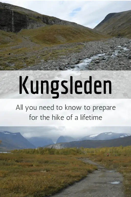
One of my favorite places on earth, the Kungsleden, in Swedish Lapland, will be open for summer hiking from June to September this year. I spent a week on the trail and surrounding areas last September and loved (almost) every single bit of it. So just before the huts and related facilities start running again, I thought it’ll be timely to compile some resources that you might find helpful if you intend to explore this otherworldly arctic landscape.
Last updated 25 Mar 2019. Please use the information below for reference only as there may be changes that I am unaware of.
Who is the Kungsleden for?
Everyone who loves nature and a good hike! The trail from Abisko to Nikkaluokta or vice versa, where most people visit, is approximately 110km (70 miles) long, and can be spread comfortably over a week.

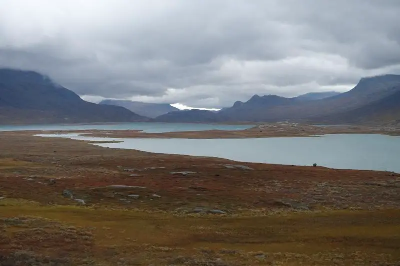
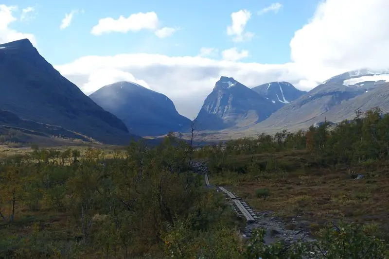
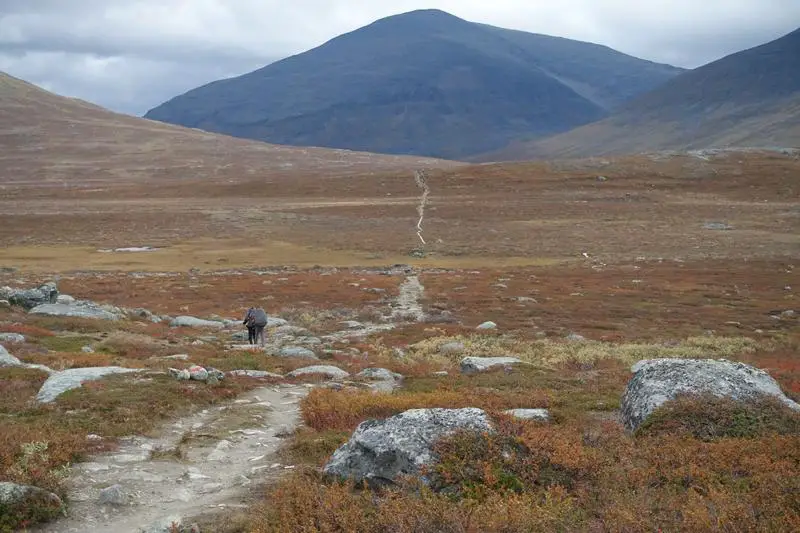
Fairy tale like landscape, even when the weather is less than ideal. Shrubs at the lower parts of the Kungsleden.
Love camping? There’re plenty of areas where you can pitch your tent and feel all alone in the wilderness. Hate camping/ carrying tents? Comfortably stocked huts run by the Swedish Tourist Association are spread throughout the hike, the distance between them ranging from 13 to 21km (8 to 13 miles).
Like it more leisurely? Complete a hut distance a day, as I saw many elderly hikers did. There are some uphills and rocky terrain but nothing too much for a day. Like it a little faster? Pack light and complete the trail in 3 days, as I saw a trail runner did. The options go on forever, but as you can see, the Kungsleden pretty much caters for everyone who wants to be out there in nature and be one with it.
When are the huts open for hiking in summer (updated Mar 2019)?
For 2019, the mountain cabins along the Kungsleden between Kebnekaise and Abisko (Singi, Salka, Tjaktja, Alesjaure and Abiskojaure) are open between 14 Jun 2019 and 28 Sep 2019.
Kebnekaise Mountain Station is open between 14 Jun 2019 and 21 Sep 2019 while Abisko Mountain Station is expected to be open all year round. Do note that, as stated on this page, that:
Full service is available from December to end of April and mid-June to mid-September but is limited in May, early June and from late September to late November.
As for the other mountain cabins between Kebnekaise and Abisko that are not on the Kungsleden, Unna Allakas, Nallo, Vistas and Karsavagge are open between 20 Jun 2019 and 21 Sep 2019, Tarfala between 21 Jun 2019 and 23 Sep 2019, and Paltsa between 20 Jun 2019 and 15 Sep 2019.
For information on opening times for huts south of Kebnekaise, click on the individual mountain cabins’/ stations’ links from the pages below:
- Information on Staying in a Mountain Cabin
- Information on Staying in a Mountain Station
- Find details of each mountain cabins and mountain stations
How long will I need to hike the Kungsleden?
As earlier mentioned, the northernmost section of the main trail is approximately 110km, with 6 huts/ mountain stations between Abisko and Nikkaluokta. Taking a hut a day would total to a week. Skipping huts is totally possible too. I wouldn’t consider myself in top fitness but I skipped huts in order to make detours to Kebnekaise and Tarfala (Tarfala IS magical) and still complete the hike in a week. The minimum number of days (more than average fitness required, but not superhuman standard) would probably be around 3, completing about 35km (22 miles) a day.
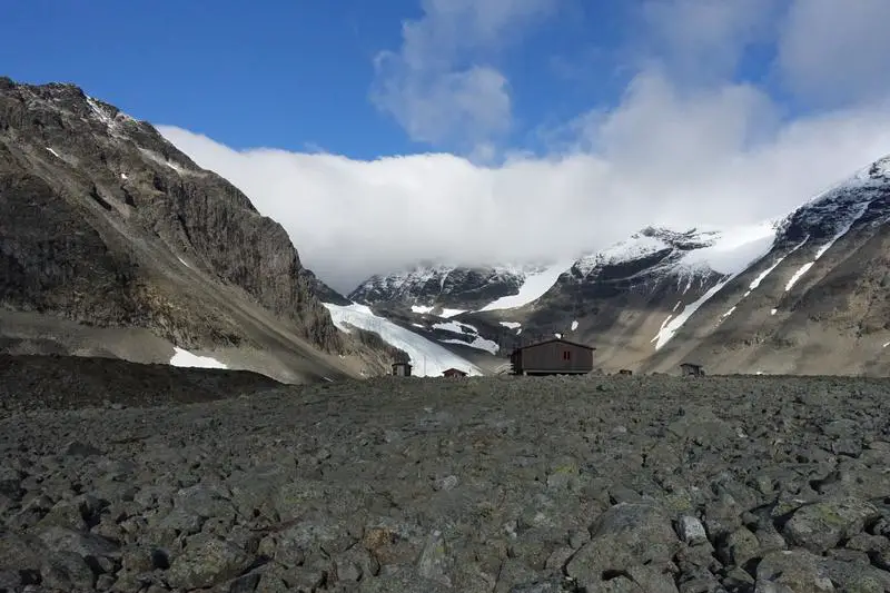
The magical Tarfala.
Have time for more? There are plenty of possible detours to stunningly beautiful landscapes throughout the trail, and you’d definitely not regret spending more time in Swedish Lapland.
Do I need a guide for the Kungsleden?
You will not require a guide to hike the Kungsleden. A guide may however add to the experience by providing additional tips and information along the way. If you’d like the time alone with nature, you’ll be glad to know that it is possible to do without a guide too. As explained below, main trails are generally well marked.
Do I need to bring a tent?
No. Huts and mountain stations can be found throughout the trail at comfortably spaced distances. You’ll need to bring sheets/ sleeping bag as sheets are not provided.
The sauna, or batsu, at Alesjaure Mountain Hut, down by the lake. The reception, bunks and toilets are in separate buildings behind me.

Is there electricity at the huts along the Kungsleden?
There are electrical plugs available at the mountain stations Abisko and Kebnekaise. However, the huts between them have neither running water nor electricity. Fret not, as you’ll always be near one of the freshest sources of water on Earth, and there’ll be plenty of scenery to keep you busy.
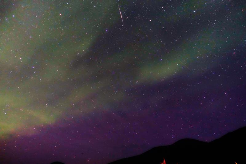
Northern Lights from Kebnekaise Mountain Station. Pardon the amateurish shot and editing, was my first experience taking pictures of the Northern Lights.
Are credit cards accepted on the Kungsleden?
Surprisingly, credit cards are accepted at major huts along the trail, as long as there is enough sunlight to power the solar generators. Maybe not so surprising considering how Sweden leads in terms of advancing towards a cashless society. Enough sunlight can be a challenge though. I met a Swedish guy who tried to get breakfast with his credit card, but as there was not enough solar power then, he had to run to the next hut (over 10km away) to get breakfast instead.
Is there mobile reception/ Wifi on the Kungsleden?
None at all. A tiny bit at Tarfala just for one of the operators, to serve the research station there studying glaciers and climate change. Wifi, like electricity, is readily available at Abisko and Kebnekaise mountain station but unavailable at the rest.
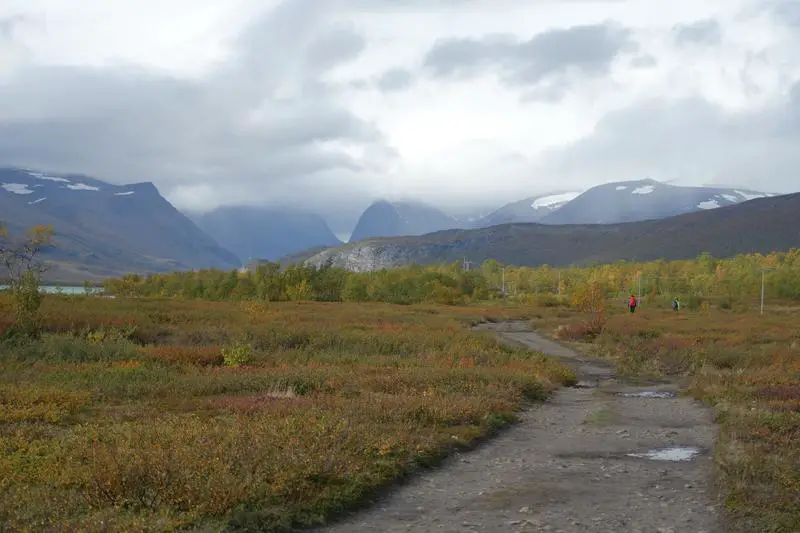
Hiking towards Kebnekaise Mountain Station, from Nikkaluokta, where the immense peaks start coming into view.
Do I need to bring food?
It is possible to get through the entire hike without bringing any food in for 2 reasons:
- Most huts on the main trail sell dried/ canned food. Pricey, a trade off between having the same food everyday and needing to carry them throughout
- Some people leave food items behind at the kitchen of the huts. Not advisable to depend on, and not really nice to take all of it as it is meant to be an exchange
Which bring me to the point on cooking. Gas stoves are available at all huts and water from nearby streams mean that you’ll most probably be able to cook almost anything you bring to the trail, without having to bring gas with you (not allowed to fly with those anyway, but you can get one at the shops for some outdoor cooking).
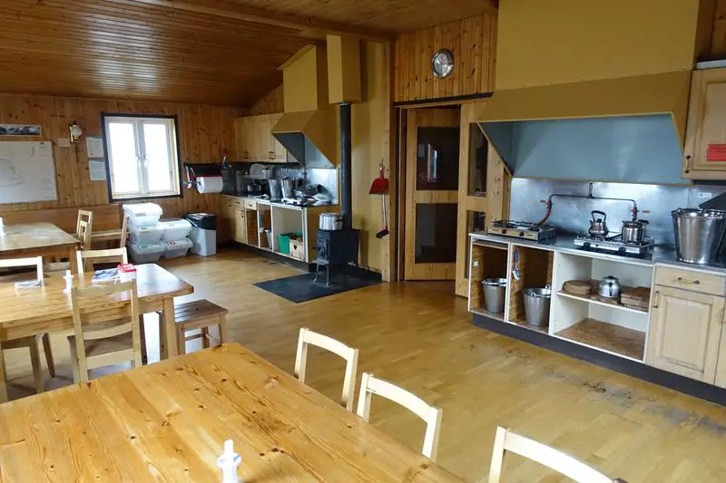
Well equipped kitchen at Tarfalastugan.
Do I need to bring water?
Nope, freshwater (apart from fresh air and breathtaking scenery) is probably the most abundant resource on the trail. Just look for clear, open streams, look around for possible sources of contamination, and if clear, drink up! A bottle would be handy for the stretches between, and to save having to leave the trail for the stream.
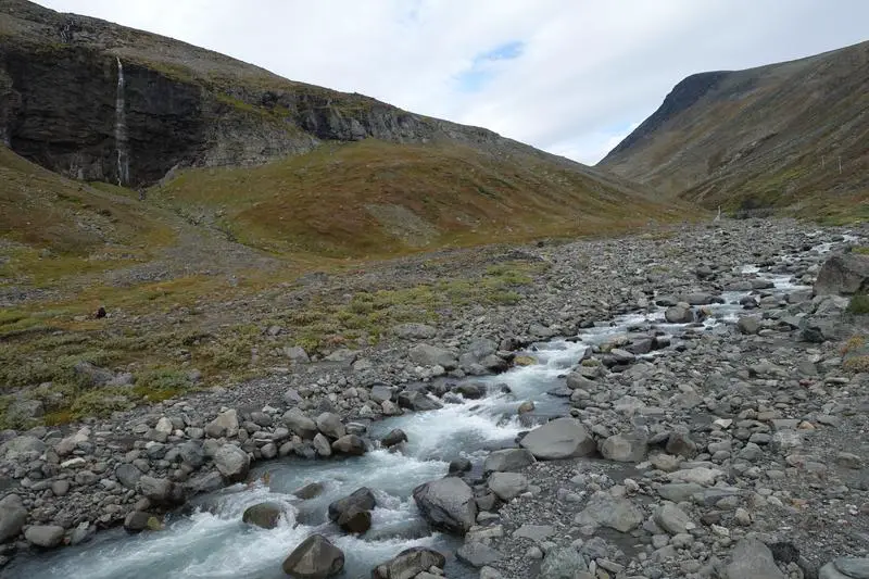
Can’t get much fresher water. These flow straight from the glaciers at Tarfala.
How do I get to the start / end?
The nearest city to the northernmost section of the Kungsleden is Kiruna. Kiruna is about 1.5 hours away from Stockholm by flight, and a day by train.
Between Kiruna and Abisko, you can choose between the bus and train. Check train schedules here.
(Updated Mar 2019) Between Kiruna and Nikkaluokta, the Nikkaluokta Express runs twice a day (in season) between Kiruna Bus Station, Kiruna Airport and Nikkaluokta. Here’s the schedule for buses:
The arrangement seems a little different from when I visit in 2016, but it appears that you can get a ~6USD discount by pre purchasing your bus ticket online. Prices for one way range from 80-150SEK (~9-16USD) online, and 130-200SEK (~14-22USD) directly at the bus, depending on your age group.
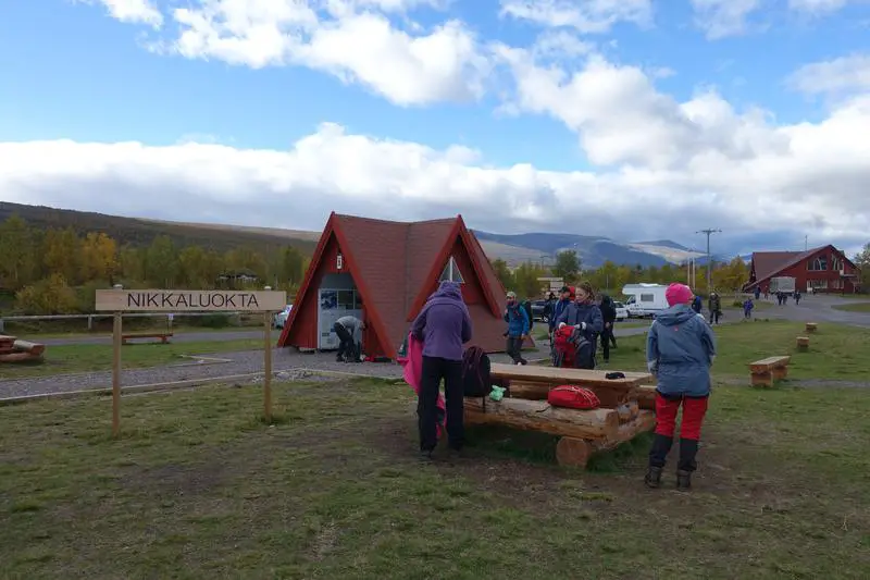
At Nikkaluokta, a popular start/end point of a Kungsleden hike.
Do I need to pre-book accommodation?
Nope. Though I did not pre-book my hut stays throughout the trail, I did not face any situations where bunks ran out. Even if they did there is an assurance that you would not be turned away. Not booking beforehand also allows for flexibility as to how long I want to spend on the trail and where I want to spend each day of it.
(Update 8 Apr 2018) It is possible to pre-book accommodation at a mountain cabin and also a good idea if you’d like to save some money (it should be cheaper to prepay). For cabins between Kebnekaise and Abisko, there are 2 kinds of prepayments. One for cabins on the Kungsleden (Abiskojaure, Alesjaure, Tjäktja, Sälka, Singi) and one for those off the Kungsleden (Unna Allakas, Nallo, Vistas, Pältsa, Kårsavagge, Tarfala, Abiskojåkka). You basically decide the total number of nights you need at each type of accommodation, set a date, and get 2 weeks validity before and after your selected date. With STF membership it will be 350 SEK a night for cabins off the Kungsleden and 450 SEK a night for cabins on the Kungsleden.
Just remember to bring along your booking confirmation as the cabins may not be able to verify your booking without it. You can prepay for non Kungsleden mountain cabins here and the Kungsleden mountain cabins here.
Night falling over Alesjaure Mountain Cabin. Alesjaure is a popular base for people wishing to explore the nearby areas.

Will there be others on the trail?
Yes, but few and far between. When I was there in September 2016, I’d go for hours without seeing a single soul, then be ridiculously happy to see someone else passing, greeting every passing person like an old friend. Maybe it’s a common experience on the trail that we don’t need words to express. If you’re there during the Fjallraven Classic between 9 and 16 August 2019, prepare for a fully packed trail. The event sells out soon after release every year.
Other hikers, few and far between, but never too far away.
Is the trail well marked?
Yes. Most of the Kungsleden is generally clear and well marked (no signage but usually a red paint mark to indicate the right path). No water crossings are required as good bridges cross the water points. There is a segment around Tjaktja Pass that was a bit of an issue for me last year though. Thick fog covered the pass and visibility was at times less than 10m, and I nearly lost the trail on a few occasions, despite the red paint marks on rocks. Take precaution there or just stay the night at the emergency hut, if the fog gets too thick.
Well marked trails. Sturdy bridges across fast moving streams. Simple bridges across slower/ gentler ones. The emergency hut at Tjaktja Pass, in September 2016.


Where are the huts and what are the possible detours?
The main and commonly used route (in either direction) is as follows:
Abisko (Mountain Station) – (14km) – Abiskojaure (Mountain Cabin) – (21km) – Alesjaure (Mountain Cabin) – (13km) – Tjaktja (Mountain Cabin) – (13km) – Salka (Mountain Cabin) – (12km) – Singi (Mountain Cabin) – (14km) – Kebnekaise (Mountain Station) – (19km) – Nikkaluokta
As mentioned, I chose to do detours to Kebnekaise and Tarfala. Kebnekaise is not really a good idea to go alone/ without snow hiking experience, but Tarfala is an absolutely stunning place, located on the shore of a glacial lake, facing glaciers on one side and mountains and a wide valley on the other.
Other popular detours are to Nallo, Vistas, and Unna Allakas, all of which are around the Alesjaure/ Tjaktja area and all of which I’d love to visit some day.
This page provides a comprehensive and detailed list of the huts in Swedish Lapland.
Is there snow on the trail?
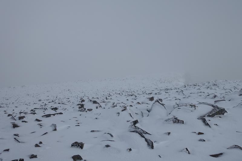
There was plenty of it on Kebnekaise and at Tarfala in September 2016, but keeping to the main Kungsleden trail you shouldn’t have to cross any snow during the summer hiking season, except occasionally at Tjaktja, the highest point of the trail.
Snow on the way to Kebnekaise. I was absolutely terrified, being alone and not having much experience with the snow, and would strongly advise against making the same mistake of underestimating how fast weather conditions can change there.
How much money will I need?
Mountain huts along the Kungsleden cost 520 SEK (60 USD) a night, or 420 SEK (48 USD) with STF membership. Huts not on the trail (e.g. Tarfala) cost 460 SEK (53 USD) a night, or 360 SEK (41 USD) with STF membership. STF membership can be obtained at the mountain stations (Kebnekaise and Abisko) for 295 SEK (34 USD), and as you can easily work out, you’d get back the cost of the membership with 3 nights on the trail. STF membership will also grant you access to use the kitchens at the huts along the trail, even if you’re not staying for the night, which would be really useful for a lunch stop if you’re planning to complete 2 hut distances in a day.
More details on pricing of huts here (Mar 2019 update: This is an old price list. Haven’t found the latest offline prices for the huts but they should have risen since 2017). That’s basically all the necessary costs of the hike.
I can’t remember to exact price of meal packets where you can just add water and have a full hot yummy meal ready, but I think they’re in the range of 100-200 SEK. There might be some clearance items on offer which can be quite a bargain in the mountains.
Approx min cost for 7 nights on the trail (last updated Mar 2019):
295 SEK – STF membership (same in 2019)
80-150 SEK – transport between Kiruna and Nikkaluokta, online price. Purchase from nikkaluoktaexpressen.se
395 SEK – 1 night at Abisko Turiststation, dorm bed, online + member price
5 * 450 SEK – 5 nights on the trail – Singi, Salka, Tjaktja, Alesjaure, Abiskojaure (or the other way)
610 SEK onwards – 1 night at Kebnekaise Mountain Station, dorm bed, online + member price (might sell out)
191 SEK – train between Abisko and Kiruna (might be cheaper closer to departure date)
Total = 3891 SEK (420 USD) including transport, excluding food
(Update 8 Apr 2018, seems to be same for 2019) Current rates for online prepayment (cheaper way to pay for cabins) of accommodation along the trail are 350 SEK a night for mountain cabins not on the Kungsleden and 450 SEK a night for mountain cabins on the Kungsleden. Dorm beds at Abisko are at 395 SEK while those at Kebnekaise range between 655 SEK and 805 SEK depending on travel dates. A closer estimate of total cost of accommodation (instead of 2940 SEK) would be 655 + 450 X 5 + 395 = 3300 SEK as of 8 Apr 2018. Refer to ‘Do I need to pre-book accommodation?‘ section on pre-booking accommodation. You’ll definitely be able to save a chunk of the cost of the hike by camping out at least on some nights with good weather.
Past edits
420 SEK x 7 = 2940 SEK for accommodation
Total = 3235 SEK (371 USD) ~400USD including transport to and from Kiruna, excluding cost of food
What do I need to bring?
Clothes
There’s a gas powered drying room (torkrum) at the mountain cabins along the trail, sufficient to dry up shoes and clothes should they get wet during the day. As such, it is possible to get through the trail with just 2 sets of warm, comfortable clothes, a set to hike in, and a set to sleep in.
Same with shoes, a good pair of hiking boots for rugged terrain with snow grip, and comfortable footwear for use at the huts/ to the sauna while your boots dry in the torkrum should they get wet during the day.
Food
If you don’t intend to spend lots of money on food bought along the trail (they cost much to bring in, given the inaccessibility by roads), don’t forgot food! Easily cooked, high energy, lightweight stuff like oats make a good choice. You can add some flavour to your oats with wild blueberries or lingonberries, which can be found in many places along the trail. Be sure that your food is not just purely functional, but also taste good enough. You wouldn’t want to end off a full day tiring hike with some bland tasting (or worse, foul tasting) food. Make full use of the stoves and pots available to make every meal more enjoyable, and don’t forget to do your dishes!
Toiletries
Speaking of which, a towel can come in handy! Make use of the wood fired saunas that can be found in many of the mountain cabins on the main Kungsleden trail to freshen up and soothe those tired muscles after a long day. Check the timings though, there is usually a women’s session, a men’s session, and also a mixed session, each for about an hour and a half. Of course, bring toiletries along to to keep fresh throughout the hike.
Equipment
Sheets/sleeping bag are essential for hygiene purposes as there are no sheets at the bunks, though beds are comfortable enough.
Never forget your torchlight/headlamp. There is no electricity along the trail and everything is absolutely pitch black once the last bit of sunlight slips behind the mountains.
A lighter or matches can also come in handy. There are wood fireplaces in the bunks and matches are not always available. Learning to start a wood fire can be very useful, but I learnt it the long way on the trail, first looking at an experienced Finnish man do it, and the next day spending hours attempting to start it myself (and accidentally finishing up quite a bit of wood).
Other essentials: cash/ credit card (to pay for the huts/ food); map (can be bought at Abisko or Kebnekaise Mountain Station); good hiking backpack, raincoat/ waterproof jacket and rain pants, camera and sufficient batteries (or just soak in the view); water bottle, mug, enough underwear and socks; books or some comfort items (e.g. earphones to listen to music); a positive attitude, and you’re all set to have the most memorable time on the trail!
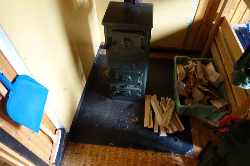
Typical fireplace in the bunks at the cabins along the Kungsleden.
Compiled useful links:
- From my hike in 2016:
- Swedish Tourist Association website to learn more about the huts and trail
- Mountain Huts Price List for 2017
- Information on Staying in a Mountain Cabin (Added 8 Apr 2018)
- Information on Staying in a Mountain Station (Added 8 Apr 2018)
- Map and details of huts in Swedish Lapland
- Train schedules between Abisko and Kiruna/ Stockholm
- Information & booking of bus between Kiruna (Airport/City) and Nikkaluokta (Updated 25 Mar 2019)
Any other questions you have about the trail that I didn’t cover? Drop me a message in the comments below!
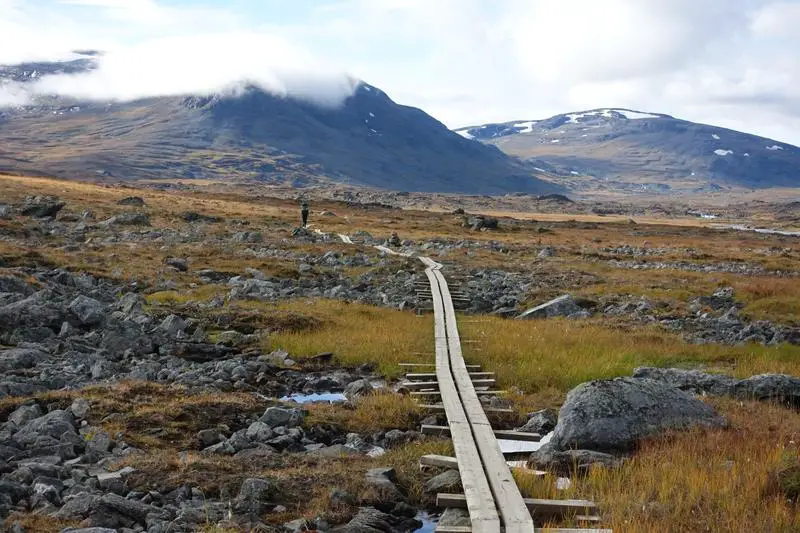
These wooden planks are the easiest to walk on.


")


Hi there, thanks for all the info. Planning to complete the whole trail this summer, but was wondering if you think its necessary to get the TBE vaccine? Also, as you went alone, did you use personal locator beacons, or is it unlikely to get into difficulty making them unnecessary?
Hi Joshua, thanks for visiting and glad the info is useful. Unfortunately I’m not sure about TBE vaccine as I did not get the vaccine. I just went to read up a little and it seems that TBE affects the southern parts of Sweden more. I’d think that if it is just between Abisko and Nikkaluokta it might not be necessary, but you should definitely get an expert opinion on this.
Regarding your second question, I think it is unlikely you will get lost if you’re hiking on the main trail between Abisko and Nikkaluokta. The trail, while not always well marked, is well trodden, so it is quite visible. Vegetation is short at this latitude so you can usually see the next cabin hours before reaching it, making it less likely that you will get lost. Something I can think of that might get you into a difficult situation/ off trail is poor weather or nightfall. There are emergency huts (usually around midway between cabins, unmanned but with firewood and a fireplace) along the way which I’d recommend using in case of bad weather or poor visibility, it is possible to stay the night there (with the appropriate sleeping bag). Getting lost in the dark shouldn’t be an issue as long as you ensure there is sufficient time before setting off to the next check point, as the spacing between cabins is comfortable. I nearly missed making it to the next cabin before nightfall twice due to poor estimation (or very good estimation depending on how you look at it haha). That said, a map would still be essential, and any additional equipment for personal safety, if not too inconvenient, is a good idea.
Hope you’ll have an amazing time, and please let me know if you feel there’s other information I should add here!
Absolutely great summary, thanks for sharing your thoughts. You actually saved me a huge headache mentioning that hiking event mid august, because I was planning hike in that timeframe.
Which leads me to my question: do you know if prebooking the huts is neccessary if you go there early August? What happens exactly if the hut is full when you arrive.
Thanks!
Hi Istvan, glad you enjoyed the article. I think the cabins should not be affected by the Fjallraven Clasic, as participants are not allowed to sleep in the cabins (http://classic.fjallraven.com/sweden/camping/). From what I’ve read, you’d not be turned away even if the huts are full but instead provided with a mattress to sleep on the floor in the cabin. However, if you wish to prebook for a peace of mind (and save some money), you can simply book accommodation for a set number of days on the Kungsleden, and these bookings can be used at any hut along the Kungsleden (between Abisko and Nikkaluokta) from a period 2 weeks before till 2 week after the selected start date (https://book.stfturist.se/en/to-do/a1137116/accommodation-in-a-mountain-cabin/showdetails). Let me know how it goes!
Thanks!
Excellent post!! We hiked the Kungsleden in 4 days this past summer and are writing a post on our blog all about how we did it. I included a link to this post of yours because we found it so helpful 🙂
Thanks Brittany! Please send me a link to your article when it’s done 🙂
Hi, very informative post. I was looking into more information on several websites and was just wondering, in terms of expenses other than equipment, food etc. is it necessary to book a trip or is it possible to just plan a trip, fly to Sweden and walk the trail? (sorry if this seems like a silly question)
Hi Luca, yup that is absolutely possible. I did not book my accommodation on the Kungsleden beforehand, and no guides/ pre-arranged permits are required. Thanks for dropping by!
We are hiking trail in late Aug.
Do we need sleeping bag for huts or just liner?
Are there blankets on bunks?
Hi Wayne! I got through the huts with just liner, no need for sleeping bags. Blankets should be provided too. I remember feeling warm and comfortable in the bunks 🙂
Hi Aaron – very informative thank you. I was planning on hiking the Abisko to Nikkaluokta from 16 – 20 Sept, however I did not anticipate hut closures before the end of Sept. As such I have now emailed the STK to get confirmation of hut opening and closing dates. Good shout!!
Paul Morton
Hi Paul, glad you found it useful. Please let me know how it goes! Thanks for dropping by 🙂
Hi, I am a student from Germany who wants to complete the Kungsleden this summer. I have some decent hiking experience from hiking in the Himalayas. I plan to hike solo. But my major concern is that hiking the entire 440 kms will take more than 2 weeks and there is no way I can afford the ~50 USD per night at the huts. If I have my own camping equipment, do you think I can avoid the huts altogether? The cost of the huts is prohibitively expensive for me. I am seasoned in pitching my own camps. Please let me know your thoughts! Awesome article by the way!
Hi Ritwik!
Yup I agree that the huts don’t come cheap! From my experience it is possible to skip the huts altogether as you can camp along the trail (there were hikers doing). There’s a really cool law in Sweden protecting the right to camp (https://visitsweden.com/about-the-right-of-public-access/)! At some parts of the Kungsleden, especially at higher elevations (eg Tjaktja, Tarfala), it might not be a good idea to camp as the conditions can be harsh.
Glad that you enjoyed the article and have fun on the hike!
Aaron
Hey Aaron,
I just discovered this trail today when looking for a new long trail to hike in Europe. Fantastic summary by the way and I do have two questions that would be wonderful if you know the answers to.
1. Do you know if dogs are allowed on the trail?
2. And, are there places to hang hammocks throughout the trail?
Those are pretty much my only requirements for picking a new trail to hike, hoping the answer is yes to both!
Thanks in advance!
Hi Taylor,
Thanks for reading, I’m happy that you’ve discovered this amazing trail! Regarding your questions:
1. Yes, dogs are allowed on the trail and cabins have separate rooms for hikers/runners with pets. From STF’s facilities page it seems that pets are allowed on most if not all of the cabins on the trail https://www.swedishtouristassociation.com/discover/?facilities. I came across hikers and runners with their dogs on the trail, though it was not common.
2. I’m not too sure about that though, as the most of the trail from Nikkaluokta to Abisko is quite barren (except the part near Abisko).
Hope this answers your questions!
Aaron
Hi,
Thanks very much for the summary and advice. I am interested in doing the hike at a leisurely pace, 1 hut a day, this July with my 12 year old daughter. I was thinking about joining an organized tour, but they are all giving a minimum age of 16. I am not sure this is because of the social nature of the tours (oriented towards adults only), or if it is too physically demanding for a 12 year old. I like the idea of the trail because it does not seem too difficult, we can skip carrying a heavy tent, and know that we are guaranteed a space in a hut any night. It really seems that we could just fly/train in and pretty start right in. Is this reasonable to do with my daughter?
Thanks
Ken
Hi Ken,
Thank you very much for your kind words. I do not remember seeing many children (at least 1 from memory) on the Kungsleden but I think if your daughter has done some hiking before the trail may be manageable. As you’ve mentioned, the trail is generally comfortable (except for some rocky sections and the occasional short uphill stretches) and you can do without carrying a heavy load. However the northern section of the Kungsleden it is still approximately 110km/70miles over a week, so the fatigue may accumulate. That may be something to consider. If you’ve more time on your hands taking extra nights at a hut you like might be a good idea too, to recharge and to enjoy nature!
Hope you’ll have a great time!
Aaron
Great information. We’re wondering if it’s possible to hike any part of the trail in March? We’ll be in the northern part of Sweden from March 22-March 27th and we’d love to do some of the Kungsleden.
Hi Molly,
I think there would still be much snow on the trails in March and might not be a good time to hike. I’m not entirely sure if there are parts that are ok to hike during that time so you might need to check with someone on the ground there. From what I understand weather conditions vary wildly from year to year too. (E.g. in 2015 the snow didn’t clear at Tjaktja for the entire year). Looking at weather trends, seems that the average temperature stays below freezing till May and the snow stays till June. It might be possible to walk around Abisko.
More details on past weather trends:
https://www.yr.no/place/Sweden/Norrbotten/Nikkaluokta/statistics.html
https://www.yr.no/place/Sweden/Norrbotten/Abisko_Nationalpark/statistics.html
Btw the projects on your site are really cool! Have a good time in northern Sweden 🙂
Aaron
Hi Aaron. Thanks for your information, very useful. I’ve got some question if you allow me:
1) How was the weather? what was the temperature?
2) Is easy to lost the track? How is it marked?
Hi Jorge,
Thank you for visiting. Regarding your questions:
1) When I visited in September 2016 the temperatures along the trail was about 0-10 degrees, with a little rain on some days, nice sunny days on others, and strong winds near Kebnekaise area. There was no snow along the main trail during that period but it got very foggy around Tjaktja pass.
2) There were not many signage along the trail then, but it is quite easy to identify the main trail, either from the wooden boardwalks, the red paint marks on rocks, or a much more clearly trodden path. The closest I got to losing the trail was at Tjaktja during the fog, where visibility was probably less than 10m and I could barely find the red paint marks on rocks. As most of the main trail between Nikkaluokta and Abisko is in a wide open valley with low vegetation it is not so easy to get lost.
Cheers!
Aaron
Hi Aaron,
Thanks for the information, those are definitely very useful! I am going to hike the pass this July, I’ve just bought the airplane tickets. What do you think is it recommended to buy the bus tickets in advance (online)? May it happen that I will be left in Kiruna without it?
Thanks for your reply in advance! I hope you all the best!
Tünde
Hi Tünde,
Glad you’re going to do this hike! I think if you’ve got the dates confirmed it might be a better idea to buy bus tickets in advance as there is a discount for purchasing online (in addition to securing your seat). I’m not sure if there is a chance you’ll be left in Kiruna without buying tickets in advance. During my trip in September 2016 the bus was quite empty, and it was not possible to buy tickets in advance then. Enjoy the hike and thanks for visiting!
Regards,
Aaron
hi Aaron, Thanks for an excellent post. I am hiking from Abisko to Kvikkjokk this July and I have given myself 9 days to do it (roughly 13 miles a day). I was planning on staying on Kungsleden throughout but you have mentioned a detours to Tarfla, Nallo, Vistas, and Unna Allakas.
May I ask
1) If I can add one or two of these detours without adding significant mileage as I need to be in Kvikjokk by end of day 9
2) Which detour would you recommend based on scenery/distance added
Thanks
Hi Arun, thank you for visiting. I’d only be able to accurately comment on Tarfala as it is the only one I’ve visited out of those options. Tarfala is possible as a day trip (although I stayed for 2 nights) from Kebnekaise Mountain Station (10 miles round trip). While I was at Tarfala there were a couple of people each day who arrive from Kebnekaise Mountain Station around midday, have a break then head back to Kebnekaise Mountain Station. I may be a little biased in saying that there’s nothing quite like Tarfala.
The next most popular option seemed to be Unna Allakas, which you can do as a detour between Alesjaure and Abiskojaure huts. This would allow you to visit Unna Allakas without adding too much mileage (10 more miles).
For Nallo and Vistas, there is a possibility to skip Tjaktja altogether and connect between Salka and Alesjaure via Nallo and Vistas, which was one of the options I had considered. This would add just 7 miles compared to the main trail.
There are other trails that add more options to these huts (eg Tarfala to Salka/ Vistas, Nallo to Tjaktja, etc) but these trails may be more difficult and less safe.
Based on my limited knowledge, for a balance between scenery and mileage I’d recommend in this order 1) Tarfala 2) Nallo + Vistas 3) Unna Allakas.
If you happen to do any of these detours please let me know how it goes so that I may share this information to other people who may be interested here! Thanks again 🙂
Fantastic information, thanks. As Grand Poohbah of the Arctic Brotherhood (www.arcticbrotherhood.org), I am researching ideas a trip above the Arctic Circle. Since 2005 we’ve done 17 adventures from Alaska to Patagonia and everywhere in between. Our group of guys are fit but are aging and we are looking to a final big, physical trip before we start scaling it back. The notion of going above the arctic circle is a big goal. However, we still want to see spectacular backcountry. Your information here was outstanding and this may be the place that delivers both.
Wow I do hope to be able to get on as many adventures as you guys some day! Thank you very much for your kind words. I think the main trail is manageable physically but there are some detours that can offer a good challenge and great views. Hope you’ll have an amazing time exploring the area!
Hi! I had a great time reading your journey! Thank you for sharing your experience!
I am very interested in hiking the Kungsleden this year (since I will be in Sweden for work), more particularly from Hemavan to Ammarnäs, though I have a question : do you think it’s possible to hike during May (from about 16th of may)? Will the huts be open? How about the weather?
Do you know where I can find these information?
Thank you for your answer, and again, thank you for this post!!
Hi François! Welcome and thanks for reading 🙂
For 2018, it appears that the huts between Hemavan and Ammarnäs will be open from 21 June to 30 September, while Hemavan Mountain Station should be open all year round. More detailed information on the huts between Hemavan and Ammarnäs can be found at https://www.swedishtouristassociation.com/learn/our-accommodation-types/stay-stf-mountain-cabin/ under KUNGSLEDEN VINDELFJÄLLEN, and information Hemavan Mountain Station can be found at https://www.swedishtouristassociation.com/facilities/stf-hemavan-mountain-station/.
Weather may still be cold, around 5 degrees Celcius on average in May according to https://www.yr.no/place/Sweden/V%C3%A4sterbotten/Hemavan/statistics.html and https://www.yr.no/place/Sweden/V%C3%A4sterbotten/Ammarn%C3%A4s/statistics.html.
It might be a better idea to schedule your hike later in the year, nonetheless hope you’ll have a great time. Cheers!
Aaron, This is such helpful information, especially the updates for 2018. We are in the U.S planning a holiday to hike and would like to hire a guide. Do you have any local referrals/recommendations? Thank you! Sabrena
Hi Sabrena, glad you found this useful! Unfortunately I do not have any local contacts or recommendations. I’ve found some companies offering tours but I won’t be able to comment about their services. Here they are:
Hope you’ll have a great time on the trail and if you happen to find a guide I’d love to learn more about your experience! Thanks for visiting 🙂
Aaron
Thanks for a wonderfully helpful site! I have been thinking of this trip for some years having done a lot of hut to hut in Norway – but always thought it too hard due to one long day at the start and having to carry food! I now see how wrong I was so hope to walk is this summer if I can. I had also found the walking companies who organised it too expensive and inclined to have rules ( maximum age and having to go in pairs!)
Hi Colin, glad you enjoyed the writeup, and hope you’ll have an amazing time on the trail!
Hi Aaron,
I am thinking about hiking The Kungsleden from mid-July to early August.. I would like to ask you, in case if you remember, what was the level of waterproofing ( in mm) and breathability (in mm) of your jacket. Do you think rainfall is a serious problem and it is advisable to invest in a good waterproof jacket?
Thanks for all the precious information in your website!
Hi Pedro, to be honest I was not well prepared for the rain when I did the hike and the jacket I brought did not have good waterproofing. I got quite soaked on the day I attempted to cross the glaciers at Tarfala (due to rain) but did not encounter much rain on the other days. However as there are drying rooms available in most cabins I was able to get most of my gear dry before starting to hike the following day. From what I gather there is likely to be more rain during mid-July to early August but nowhere near the rainfall of the tropics (even in the month of the highest rainfall in Nikkaluokta the average rainfall is still less than the month with the lowest average rainfall here in Singapore). A good waterproof jacket can add more comfort on those days (assuming it is not too heavy to pack) and keep you from falling sick, but I’d say having a basic waterproof jacket should be sufficient for this hike 🙂
Hi Aaron,
What are the temperatures like during summer months?
Thank you,
Jenny S
Hi Jenny,
The temperatures in summer should be around 5 to 15 degrees Celcius (41 to 59 degrees Fahrenheit), a little warmer towards the south (Nikkaluokta).
Aaron
Hi Aaron
Thanks for sharing your experiences and all that info so helpfull thanks again.. I plan to hike from Abisko to Nikkaluokta in early July. My question is.
Are boots needed and neccessary? or can i hike with trailrunners with out problems?
Thanks.
Gøkhan
Hi Gøkhan,
Boots are not absolutely necessary, I came across a few people who did the Kungsleden using trail runners, they seemed to be doing fine. The trail is quite rocky and slippery at some parts so just need to take more care! If you’re keeping to the main trail you should be fine. Have a good hike 🙂
Aaron
Hi, thanks so much for writing this blog, its been really useful! I’m going to take your advice and go to Tarfala.
Thank you for your kind words, and hope you’ll have a great time!
Hi, I will be hiking the trail with my 12 year old daughter in the next couple of weeks. I will be finishing at Nikkaluokta. The last boat trip we can make across lake Ladtjojaure is at 215pm, since we have to be on the 450pm bus trip back to Kiruna. How long do you think we need to hike that last leg to the lake by 2pm? I want to make sure we leave early enough in the morning from the Kebnekaise mountain station.
Thanks
Hi Ken,
I’m not too familiar with the boat and did a quick lookup, it’s 19km between Nikkaluokta and Kebnekaise, approximately 5km between Nikkaluokta and Ladtjojaure and 6km across the lake, so I suppose it is about 8km from Kebnekaise to Ladtjojaure. At a really comfortable pace of 2km/hr that should be about 4 hours. I think you should be able to complete it in less time than that as it is a gradual downhill/ flat. But I am not 100% certain that it is 8km from Kebnekaise to the lake though, you may want to check with the company doing the boat trips at [email protected]. Alternatively at Kebnekaise the staff there should definitely be able to provide information on that. If you find out more information about the boat trip please let me know. Thank you!
Extra resources:
http://nikkaluokta.com/en/about-us/faq
http://www.enoks.se/en/boat-departures/
Regards,
Aaron
How many hours of walking each day if need to complete in 4 days.
25k??
Hi Ranbir,
If you need to complete the trail in 4 days, a possible split could be (assuming a walking speed of 2-3km per hour):
The last 2 days are likely to be the more tiring one, 3rd because of the uphill and 4th because of the distance. If you’re very fit you’ll probably be able to complete the distances in less hours than described. Also possible in reverse.
Have a good hike!
Aaron
Dear Aaron,
Thanks a lot for your insights. With a friend I am planning to hike the Abisko Nikkaluokta trail mid September. We were wondering if there are other options to reach Kiruna from Nikkaluokta then the bus? are taxis available? would you know the costs approximately? We will walk the Kebnakaise to Nikkaluokta part of the trail on the Friday and we have to be in Kiruna that same evening (otherwise we miss our flight on Saturday in kiruna in the morning). I am afraid we will miss the last bus at 4.50pm.
Thank you for your help!
Hi Camille,
I’m not 100% certain, but I think you can call for a Kiruna taxi when you arrive at Nikkaluokta (or when you get cellphone reception), though it is likely to expensive. From the Kiruna Taxi page (http://taxikiruna.se/priser/), there isn’t a given price for Nikkaluokta to Kiruna (70.3km), and the longest trip with a listed price is Kiruna to the Icehotel (18.7km) at 495 SEK (48 EUR/ 56 USD), so I guess the price for Nikkaluokta, if available, will be significantly more than that. You can confirm the prices with them at [email protected] or 0980-12020.
From this forum (https://www.utsidan.se/forum/showthread.php?t=86102) it is suggested that the Airport to Nikkaluokta by taxi is 1300 SEK (125 EUR/ 146 USD) so I suppose the reverse might be similar.
I think if you leave early from Kebnekaise perhaps at 7am or earlier you should have more than enough time to arrive at Nikkaluokta before the last bus.
If you happen to find out more about the taxi/ prices please let me know so that I can share the knowledge. Thank you!
Have a good hike 🙂
Aaron
This is a very useful site, thank you so much
Welcome! 🙂
Hi Aaron,
Thank you very much for the info, it’s very useful.
We are a couple considering taking the trail, we have around 3-4 days, it is possible to hike only part of it? if so, which part would you recommend? We are not in the best of shape..
Thanks and regards,
Shani
Hi Shani,
Welcome, glad you found it useful. As discussed in our chat, a couple of possible options that won’t be too strenuous (along the stretch between Nikkaluokta and Abisko) are:
And, a nice route you found, heading south from Nikkaluokta:
Have a great hike!
Aaron
Amazing blog – very informative. Can I ask how easy it was to communicate: English is my first language and I speak a little French and Spanish but no Swedish. Also I want to do the the whole trail to Hemavan- do you know what cheapest option of travel is from Stockholm to Abisko and back from Hemavan. Finally is it worth joining Stf if I plan on camping all the time beside huts and do they sell screw on camping gas cylinders.
Hi Lee,
Thank you! Regarding your questions:
Hope the above is helpful! Have a good trip 🙂
Aaron
Hi, I’m traveling the Nikkaloutka to Abisko segment this September and I’m very confused about the clothing. What kind of outer layer should I use? A hard shell? And if so, of what quality? Will 150$ one will do? Or do I have to invest more?
Hi Idan! It’ll be better to have a waterproof layer as it may rain in September. It depends on what you can get with $150. I don’t think you’ll need an expensive one as the weather shouldn’t be too harsh on the main trail. What I use nowadays is a warm inner jacket (-5 to -10 degrees celcius, a little extra allowance to feel comfortable) and a light raincoat, which together cost under US$70 in Singapore (from Decathlon). A similar set up should be sufficient until the end of the summer hiking season.
Hi Aaron,
Great article.
I’m planning to hike the northern part of the trail : Abisko to Kvikkjokk around mid September to complete my last journey done a few years ago (I went from Hemavan to Kvikkjook).
First question : do you think it is better to start in Abisko and go south or Kvikjokk and go north ?
Second question : is it possible to do all by walking or will I need to take a bus ? Also are there any boatmen you need to call to cross lake (it was the cas near Kvikkjokk) ?
Last question : will two weeks be enough (or too long / short) ? For your interest it took me two weeks to do Hemavan – Kvikkjokk.
Thank you so much for your answers !
Donatien
Hi Donatien! For your first question, some things to consider:
Some people start from the north and head south to enjoy the sun in their face, while others try to avoid that. I did south to north as transport out of Lapland via Abisko is more convenient and so I’d have greater flexibility in doing the trek without worrying on reaching at any specific day or time. However it may be colder as you head north especially late in the season, so that may be something to consider. When I did the hike 2 years ago it felt like there were less people heading south (still were some people though), so the crowd may be something you’d want to think about too, though in September I think the crowds should be much lesser.
Regarding your second question, I’m not too familiar between Kebnekaise and Kvikkjokk as I only did the part northwards from Kebnekaise. However I believe you will be able to complete the entire trail by walking and with some boat crossings. This page has excellent information on the crossings that are required between Kvikjokk and Kebnekaise (https://www.swedishtouristassociation.com/learn/boats-in-the-mountains/).
For your third question, I think it will be enough, but possibly a little rush. As mentioned above I have not done the section between Kvikjokk and Singi, but it appears that 1 week should be just right for a hut a day. Northwards of Singi you can complete it in a week by doing a hut a day, and that should be relatively comfortable. If you’re in a hurry Singi to Abisko to can be done in as short as 3 days (super rushed, I wouldn’t advise it). So 2 weeks should be enough to complete the trek.
Hope these are helpful, and enjoy the trail!
Hi Aaron,
This is an excellent resource! Thanks for your efforts.
I realise mobile coverage is limited on the Kungsleden, but what is the best mobile service company that will pick up the most reception? Also, are there any technical mobile coverage points to be aware of eg. for organising lake crossings? (we have already researched the crossing times, prices & contacts)
We have booked our flights to Narvik Friday 17th & will be begining the Kungsleden in Abisko Saturday 18th August heading south to Hemavan.
Thanks in advance
Tegan
Thanks Tegan, glad this has been useful. I’m not too familiar with mobile coverage but from what I understand 2 years ago, there was zero coverage for almost all of the areas I went to except for Tarfala where there was limited reception for one company. I can’t remember which but it might be Telia. There was however Wifi at Kebnekaise Mountain Station (and possibly the other mountain stations). For the limited areas with connectivity Telia might be the best bet. You may have come across this page, but if not, I think it has the stuff you’ll need on calling for boats (https://www.swedishtouristassociation.com/learn/boats-in-the-mountains/). All the best for your trek!
Hi Aaron
I’m interested in the Kungsleden both as a hiking route but also as a skiing trail in the winter. Do you know anything about skiing the route?
Thankyou for your helpful article.
Hi James,
Unfortunately I’m not familiar with skiing the route, but yes as you mentioned skiing is possible in winter. Hope you’ll be able to find the information and have a good time!
Aaron
Hello there 🙂 I am also planning to go to Kungsleden in September. I will travel with my tent and I’m going to stay in random places on the trail, but my question – do there is showers in cabins (I read about sauna) Can I use a sauna and shower, if I’m not staying in a cabin and how much it could cost?
Thank you for all advices Aaron, what you have given here, I found them very useful!
Inese
Hi Inese!
Thanks for reading, glad you found the information useful 🙂
I’m not sure about the sauna exactly, but if you are a STF member you’ll be able to use the cabin facilities such as the kitchen, toilet and drying room for a couple of hours in the middle of the day for free (https://www.swedishtouristassociation.com/learn/our-accommodation-types/stay-stf-mountain-cabin/). For non-members the use of these facilities is 100 SEK. There aren’t specific shower rooms at the cabins (only at mountain stations) but there is heated water available (in a big container) at the saunas.
Do let me know how it goes, and have a good trip!
Aaron
Hi Aaron,
I am planning to go to the Kungleden. But I have a question; when you start for example in Abisko and finish in Nikkaluokta, are there going busses from Nikkalukta back to Abisko? Or do you have to hike back to Abisko?
Thank you for all the advices. I found them very useful!
Mats
Hi Mats!
You can take the bus from Nikkaluokta to Kiruna after ending your hike at Nikkaluokta. In the summer season in 2018 it seems that there are 2 such buses a day, one around 11:50 and the other 16:55. Thanks for reading!
Aaron
Hey Aaron, wanted to thank you for your excellent post on Kungsleden. We took our three year old on it this summer just gone. Didn’t quite make it but not through want of trying. We also went to Tarfala which was stunning.
Have a look if you’re interested (http://www.journeysetc.com/?p=1791) and thanks again.
Richard
Hi Richard! Really nice to read your post and relive the amazing trail, and awesome of you to have done it with your kid! Thanks for sharing your experience, glad everyone had a good time – definitely more important than finishing the trail 🙂
Hey
Your post is really helpful for us:)
Just one question: If I only sleep in tents and not in huts, do I have to pay to hike the Kungsleden or do I only have to pay for eating and drinking?
Hi Lara, thanks! There are no fees for hiking the Kungsleden. For pitching tents as long as you are not pitching within the immediate surroundings of cabins there should not be any charges too. It’s related to Sweden’s Freedom to Roam laws, which are really cool! Have a good hike!
hey Aron,
thanks for all the info on the kungsleden. I plan to hike the northern part from abisko to nikkaluokta.
I looked at https://www.macsadventure.com/holiday-1888/the-kungsleden , but it is not possible to book this trip as a solo hiker.
is it safe to walk alone?
i have hies alone before but never such a remote area
Hi Magreet, it is safe to walk alone on the Kungsleden. If you are concerned I’d advise to keep to the busier hiking period in the middle of summer. During that period you should find sufficient company, especially along the main trail between Abisko and Nikkaluokta. With cabins spaced out around every 12-16km you’d never be too far from help too (at least in summer when the cabins are open). You’ll do fine 🙂
Hey Aaron,
thank you so much for your great article. I am planing to hike the entire Trail in July/ August 2019 🙂 I am a solo hiker and I’m wondering about how necessary a map is. In your article you describe a map as an essential. My questions after reading your article (especially the part “Is the trail well marked”) are:
– Did you really use your map?
– Did you buy the map at Abisko?
– How much did it cost?
– Do you have an Idea, if I can buy other Maps along the Trail, so that I don’t have to carry all maps the entire Trail (I understand that you didn’t do the hole Trail but I hope that you maybe talked to other hikers about this 😀 )
Thank you again for the work you have put in to this page!
Hi Alina! If you’re keeping to the main trail it might be possible to skip getting a map. Alternatively if you have some offline map app for your phone that should do too. I used the map mainly for checking that I was on track, to estimate how far I had to walk to the next checkpoint, and roughly check which side of the valley/river I should be on. Also as I had originally planned to take a side route I was using the map to check how that would work out.
I got my map at Kebnekaise Mountain Station but I think you should be able to get it at Abisko too. Just dug out my map, it was 159 SEK in 2016 (approx 17.5 USD/ 15.5 EUR). If I did not remember wrongly there was only one map that covered the hike.
If you are considering to skip getting a map, I think the best bet would be an offline map app. That would also have the added advantage of working in bad visibility. If you are an experienced hiker with a decent sense of direction, you may consider not getting any (might be risky). I think there should be other hikers along the way at the time you’re hiking so you should be able to see which way is the right direction.
Thanks for dropping by, let me know what works out for you! 🙂
Regards,
Aaron
Hi Aaron
Wonderful website.
We’re a family with four children (between 11 and 16 years old) and we’re planning to walk the Kungsleden in august. The Flellraven Classic will be organised on august the 9th untill the 16th.
How can we avoid this massive event? Is there an alternative route? Or is it enough to leave on the 6th of august?
Thanks and best regards,
Christophe Dael
Hi CHristophe! Thanks for dropping by 🙂 It seems that the Fjallraven Classic has start groups from Nikkaluokta from 9, 10 and 11th August this year, so if you’re also heading from Nikkaluokta to Abisko, you should be able to avoid the crowds if you start your hike on the 12th or later. Alternatively leaving on the 6th or earlier should be fine but I’m less sure, as I know that there are people who are able to complete the route in 3 days so if there are many such people the second part of your hike may get a little crowded. Unfortunately I do not have experience with the Fjallraven Classic to be able to advise on more details on the expected pace of participants.
For alternative routes:
Kungsleden: Salka – Tjaktja – Alesjaure
Alternative: Salka – Nallo – Vistas – Alesjaure
Kungsleden: Alesjaure – Abiskojaure
Alternative: Alesjaure – Unna Allakas – Abiskojaure
These are the more well known detours that may help you avoid the crowds on the main trail (if it gets crowded).
Hope this is helpful, and hoping to hear how it goes for you! Have a great trip 🙂
Hello Aaron,
Firstly, thank you very much for all the detailed information about your trip to Swedish Lapland. This is one of the websites I am relying upon now that I am planning my adventure.
My trip would also involve Nothern Norway as well as Sweden and I am wondering if you used any specific paper map? If so, which one? I know paper maps are the the most reliable way to navigate, but there so many, one for each section of the trail that it is a bit too much.
Any thoughts? Very much appreciated,
Nathalie
Hi Nathalie, glad to be able to help!
I used the map for Kebnekaisefjällen, which I purchased at Kebnekaise (they have other maps too). It covers a little bit of Norway, up to Narvik, and for the Kungsleden it covers the area between Abisko and Vakkotavare. The list of included areas are: Narvik, Riksgränsen, Abisko, Ritsem, Sitasjaure, Kaitumjaure, Teusajaure, Vakkotavare and Saltoluokta. I’m guessing you’ll need another map for anything further than Narvik, but from Nikkaluokta to Abisko this map comfortably covers all of it.
You may want to consider one of the free offline hiking map apps. Since last year I’ve been using Maps.me as my primary navigation tool with physical maps as backup. In airplane mode it doesn’t seem to use up much battery and so far seems pretty reliable for hiking routes (Google Maps didn’t seem to have much for hiking routes). I just checked, Kungsleden seems to be available in Northern Sweden, and there are Northern Norway maps available too. One downside is that it doesn’t provide the topographic detail physical maps provide.
Hope this helps, and enjoy your trip!
Hi Aaron, Thanks for all the helpful information. I am planning to hike the northern section this September and was wondering about the connection from Nikkaluoka to Kiruna Airport. I see there is a bus that gets you to the airport at 12:50pm and then the flight to Stockholm is at 1:40pm. Is that enough time to make that connection? I would imagine the airport is small but you never know about the security check, etc. Thank you, Mo
Hi Mosmall, I don’t remember there being extensive checks/ processes when I was there (few years back), but there was still a queue as 2 flights were scheduled at almost the same time. You may want to check the latest check in time for your flight, as well as whether there are other flights scheduled around the same time. Other than that, it should be as what you’d expect from a small airport (assuming things are the same). Cheers!
Hi there. Thanks for sharing. 3 questions :
1. How is wild life up there? Any risks? Considerations of that.
2. Is it possible to do the whole trip by yourself?
3. How cold it gets if you camp at night outdoors?
Thanks Albert
Hi Albert!
1) The most common animal along the trail are the reindeer herds towards the north that should pose little danger as long as you keep a safe distance from them. Wolverines are also present on the trail but I did not come across any. I would say the wildlife risk is pretty low on the trail.
2) Yes, it is possible to do the trip on your own. Most of the trail between Nikkaluokta and Abisko is clear, but you’ll still need a map and some navigation skills.
3) In the middle of summer it’ll probably be about 10 degrees Celsius but by late September it’ll be around 0 degrees Celsius at night.
Hope this helps, have a good trip 🙂
Regards,
Aaron
Hi Aaron, thank you for sharing all the information.
I have one question, since I am traveling to few other countries in Europe as part of my extended holiday this august, I will be carrying a very large suitcase. The king’s trail hike is so tempting. Would you know of cheap places or ideas on how I can leave my suitcase in Stockholm or at one of places in the hike for ease and return back to collect it? I have not decided where to start and end, since I am still researching. I arrive in Stockholm on 5th and leave from Copenhagen on 14th of Aug. Thanks again
Thank yo.
Hi Sherry!
You can try checking with your accommodation in Stockholm or Kiruna if they will be able to store your suitcase, some may charge for it. Either way it’s likely that you’ll pass by Kiruna and Stockholm again so it should be convenient. Alternatively, according to the STF Abisko Turiststation page, you should be able to leave your luggage at Abisko, though that would mean having to make a detour after the hike back to Abisko to retrieve your bag. Stockholm airport may be another option but the charges seem pretty steep.
Hello!
Thank you very much for all the useful informations! I’m planning to go from Abisko to Nikkaluokta this August.
In all the websites I visited,I found informations about one single path,passing through alesjaure and sälka and kebnekaise. Do you know if it is possible to reach Nikkaluokta following Visttasvaggi? On the map there is the symbol of a way in that direction…
And do you know if there will be fire bans this summer?
Thank you very much!!
Hello Aaron,
thank you for all the useful informations! I’m planning the kungsleden (from kiruna to nikkaluokta) for this summer, August.
In all the websites I visited I found informations about thecommonly used route that you also described (the one passing through Kebnekaise). Do you have any information about the route following Visttasjohka (Visttasvaggi)? I know there are no hut in that way, but I’m planning to bring with me a tent, and I think that one will be a little shorter.
And do you know if there is fire ban planned for this summer?
Thank you very much for the informations!
Paolo
Hi Paolo! Unfortunately I do not have experience on that route. From what I can find, you can start from Alesjaure towards Vistas, which is about 18km. There are beds, a sauna and provisions at Vistas. From Vistas it is 33km to Nikkluokta, might be possible to complete in one long day. I’m not sure about fire bans this summer though.
Hi Aaron!
Thanks for the very informative summary of your hike! I have two questions for you. First, I plan on camping throughout the entire trek, do I need to book in advance to hike the trail? Second, I have 4 – 4.5 days to complete the hike – is this manageable? I’m a relatively experienced hiker and I’m in reasonably good shape. Thanks!
Cheers,
Scott
Hi Scott!
Welcome! Glad to be able to help 🙂 You will not need to book in advance especially since you’re camping as there is no limit on/ fees for people on the trail. 4-4.5 days should be sufficient if you manage 20-30+ km per day, which is quite possible as the terrain is relatively flat (still some ascents). Have a good time!
Regards,
Aaron
Hi Aaron!!!
I am planning to trek Kungsleden from 6th-12th of September (from Abisko to Vakkotavare) and I have a few questions.
1 .First of all i am not sure if doing in 5 or 6 days (I am quite fast hiking, but not sure if just take and extra day with me). My plan is to go with my own tent.
2. Can I reach the starting point of the trek (I would start in Abisko) by the train from Stockholm?
3. Where can I buy some camping gear like gas for cooking, lighter…before starting the trek? Would be possible in Abisko? (I think i will arrive around 3pm at the Stockholm airport (Arlanda) and the train is at 18pm, so not sure if I am going to have enough time to buy that things in Stockholm)
4. Is there any chance in these dates to see northern lights?
Thank you very much!! 🙂
Regards,
Marta
Hi Marta!
1) I think either is fine if you’re hiking fast. With the extra day you might want to consider some of the side trips (e.g. to Kebnekaise or Tarfala).
2) Yes, from Abisko Turiststation it is just a few minutes to the start of the trail.
3) You should be able to get camping equipment at STF Abisko Turiststation, also a few minutes from the railway station. There is a shop in the main building which sells such gear, subject to availability. Even if they’re out of stock, some of the cabins along the trail might have stock (wider range at Abiskojaure, Alesjaure and Salka). Here’s a full list of products and their prices: https://www.swedishtouristassociation.com/app/uploads/sites/2/2019/05/prislista-2019-large-eng.pdf
4) Yes, as long as it is a clear night there is a good chance of seeing the northern lights along the trail.
Have a good trek!
Regards,
Aaron
Thank you very much Aaron for such an useful information!! 🙂
Do you remember if there were plugs in the train or huts for charging gadgets?
Hi Aaron,
Thanks for the guide! We’re headed to Sweden next week to do the trail and I know you mentioned not needing sleeping bags, but I’ve also found some mixed information so was curious what the bedding situation was? We have sleeping bag liners but if we don’t actually need to bring the sleeping bags that would be excellent. Thanks!
Hi Anna, if you’re sleeping in the mountain cabins/ stations, having bed linen is sufficient as mattresses, pillows and blankets are provided. I think sleeping bag liners should be fine. You can read more details on sleeping at a mountain cabin here: https://www.swedishtouristassociation.com/our-accommodation-types/stay-stf-mountain-cabin/. Have a good hike!
Hi Aaron. Just found your site and it’s excellent. What a phenomenal number of links you provided – THANKS! I will go for the hike in mid-August 2019 with my wife (right after the annual event ends) so the trail will be well-trampled but absent too many people, I trust. As for Brittany’s blog that you asked her about, I found it: https://mrandmrsadventure.com/2018/01/11/midnight-sun-tips-itinerary-hiking-kungsleden/
Thanks again for your posting!
Welcome! Glad to be able to help with the planning, it can feel overwhelming sometimes. It’s a big adventure and I’m sure you’ll have a great time. Thanks for the link!
Hi Aaron – Thanks for all the useful info.
I am planning a trek from Nikkaluokta to Abisko end of Aug. to beginning of Sep. Not sure what clothing is required. Planning on taking for upper body a long sleeve shirt, micro-fleece with hoodie, down jacket (soft shell) and thin rain gear(hard shell).
Lower body – hiking pants and rain pants, water proof hiking shoes.
Will this keep me warm enough or am I overdoing it?
Planning to sleep in the cabins along the route.
Thank you
Hi Ahmir, the temperature will probably hover around 0 at night and around 10 in the day. Your set up seems fine, might just want to check their temperature rating to see if they’ll hold up to the lowest expected range (with some allowance), and plan for top layers you can easily take off/ put on should weather conditions change. The cabins should be warm. Have a good hike 🙂
Hi Aaron, like others i’m very grateful for all the information you’re sharing on this site. We’re planning to do the hike in two weeks and I’m wondering how much mosquitoes and other insects there will be and, more importantly, what we can do about them to ensure it will be a pleasant hike.
Thanks, Roel
I take pleasure in, cause I found just what I
used to be looking for. You have ended my 4 day lengthy hunt!
God Bless you man. Have a great day. Bye
Welcome!
Hi Aaron,
thanks for all the info.
One thing i wanted to ask you about is how bad the mosquito situation is on the trail around this time. We’re going to walk the trail in about a week and wondering how much we should stock up on Deet and other countermeasures 🙂
Thanks!
Hi Roel,
Apologies for the delay. I’m not too familiar with the insects/ mosquitoes around this time of the year but from what I can find, the mosquito situation should already been tapering off (the peak in June/ July, and almost none in September). Some measures should be good but probably don’t need to prep too much for it, especially since you’re going almost in September. Have a good hike!
Thanks for this write up, excellent info!
Welcome!
Hi Aaron thanks for all the informations. I’m going to do the trekking from Abisko to Vakkotavare from the 19th to the 25th of September and I wanted to know if the STF huts are still open, because you wrote that until the 28th they are still open, but on the STF website they are closed.
Could you help me in some way?
And how can I reach Stockholm from Vakkotavare avoiding plane?
thank you
Roberto
Hi Roberto! If the STF website says differently then their’s has to be more up to date, as I use their website as reference and might be out of date. To get to Vakkotavare from Stockholm, you can take the train to Gällivare, then bus 93 to Vakkotavare. Have a good hike!
Hi Aaron,
Can I check with you what’s your take on the trail difficulty of Kungsleden – in comparison to the one you did at Lake Baikal (from Listvyanka to Bolshie Koty)?
I did the latter during winter before and came out of it realizing that was out of my league 😡 I’m interested to hike the Kungsleden although I don’t know if that’s doable for me given my prior knee injury since it’s a multi-days hike. The only multi-days hike I tried is the Nakasendo trail during winter, I’ve mainly only done day hikes – eg. Halla-san, Dragon’s Back trail, and Lantau Peak.
Thanks!
Hi GQ, apologies for the late reply, I had missed your message. From my experience with both I’d say the one at Lake Baikal is easier, but I had did it in really nice summer weather. Given your experience the Kungsleden should be fine in summer (not easy, but doable). Some parts of the Kungsleden are rocky and slightly more difficult to walk on, but there are not many ascents or descents unlike most other trails. Probably not a good idea to attempt in less than perfect weather if you’re not confident. Hope you’ll have a good time!
Thanks for the info and comparison =)
Welcome! 🙂
Amazing post!! Thank you.
I’m planning to travel with my children so I thought to spend something like 2 or 3 nights.
Is it possible? Do you have recommendation where to start and where to end?
Thank you in advance…
Amir
Hi Amir, thanks you! For 2 to 3 nights I think it’ll be a good idea to start and end at Abisko. You can base yourself there and do day trips around the national park, or head out to the cabins within a day’s walk from Abisko, such as to Kårsavagge or Abiskojaure, and head back to Abisko the following day. Have a good trip!
Hi Aaron
I enjoyed your info .. getting it solely from those who sell is not always comfortable.
I’ve been planning a fishing/kayak tour on Kaitum using experience from two earlier fishing-hikes +20 years ago. I’ll not be able to carry all my luggage since it now also includes a home-made foldable kayak, so I’ve made a trolly for the purpose! Taking on Kaitum from the train-station (of same name) going upstream is not an attractive option due to the terrain. I think that my best hope is entering at Nikkalouokta and follow Kungsleden to Kaitumjaure Fjellstuga in anticipation that the trail is better acessible from the trolly point of view.
It will probably be a small miracle if I don’t have to make retourn-tours on the worst parts of the trail .. how would you estimate the problem?
The trolly has 50 cm diameter wheels and everything else can be customized to optimal usage for the situation.
Hi Carsten! Wow that sounds like a real adventure. Unfortunately I am unfamiliar with such a situation and also for the trail south from Nikkaluokta, but here’s what I found. According to this page (http://www.distantnorth.com/destinations/kungsleden-trail-how-to-get-there/), the next possible exit down south from Nikkaluokta is at Vakkotavare, about 23km further from Kaitumjaure. From there bus 93 can get you to the train station at Gällivare. I’m unable to advise on the trail conditions for that part of the trail though, maybe the Swedish Tourist Association can help?
Hi Aaron,
I’m from India, and while going through internet, I find this Trail. And then I Come across the beautiful description you just gave, simply brilliant, so much information. I wish someday I’ll be there to Bingung those Terrain…
It was a really pleasure to find so much description from a first hand hiker…
Thanks…
Hope you guys are Well and Good…
Stay Home, Stay Blessed, Spread Love…
Hi Sayan! Thank you for your kind words, hope you’ll have an amazing time on the trail 🙂
Hello
Can I pitch a tent where ever I want ? And can I make fire near the tent or fire is allowed only in the huts ? Do I need any permissions to do the hike and to make fire on my own ?
Hi Kishan! Yes you can pitch a tent almost anywhere. However if it is near to the mountain cabins, non-members (of STF) may need to pay some fee. More about right to access in Swedish nature here: https://visitsweden.com/what-to-do/nature-outdoors/nature/sustainable-and-rural-tourism/about-the-right-of-public-access/ As for lighting fires, small fires are generally fine, but you will need to check if there is a fire ban in place: http://www.swedishepa.se/Enjoying-nature/The-Right-of-Public-Access/Det-har-galler/Lighting-fires/ Have a great trip!
Hi Aaron,
First of all, thank you for sharing all your experiences with everyone! I was planning to do a trail in Switzerland at first, but you convinced me to go further north.
I plan to go on a tour with a group of 4-6 friends next summer. We are all used to marching decent distances with heavy backpacks and orienting ourselves on a map and landscape. We are looking for both a challenge (in terms of distance, but also in terms of difficulty) and a beautiful tour to walk along. However, we have no experience with glaciers and snow landscapes. We have a total of 10 days to walk a route, so we would go further than 110km. We would bring our own tents and equipment to stay flexible and free in terms of distances. We are looking for a challenge as well as beautiful views and nature.
Do you think the Kungsleden has all this to offer?
With kind regards,
Matthias
Hi Matthias, glad you enjoyed the post! I think the snow conditions at Kungsleden are not so predictable. From what I heard, around Tjaktja, the snow never melts fully on some summers, while on other years (like the one I was there), there was no snow around the pass in summer. There may be more snow around Tarfala but apparently not so consistent too. You’d still be able to see snow in the distance/ on the mountain tops even if the paths are clear. However I’d advise against hiking through snow/ across glaciers without prior experience as it is quite dangerous.
As for finding a challenge, I would think that the main trail may not be sufficiently challenging for you, but I am not able to comment on whether the side trails would provide that challenge as I haven’t done them. Maybe you can zig-zag around the main trail to explore the less trodden side trails, adding to the distance and challenge. Scenery wise I haven’t quite come across anything like the Kungsleden.
Hope you’ll enjoy it!
Hi, could you please let me know if the payment for the tent is required if we want to camp next to the hut and use the kitchen facilities based on the STF membership? We are planning to go in August.
Thank you.
Hanna
Hi Hanna, for campers next to mountain cabin, there is a currently a service charge of 250SEK per adult per night for STF members. One possible option for a tighter budget might be to pay the service charge for day visit without accommodation (40 SEK for adult STF members), then camp beyond the mountain cabin compounds. You can find more details on this here and here. Hope that helps, and have a good trip!
Hi Aaron, I am from Singapore too, may i know how did you get to Abisko from Singapore? Trying to compare different modes of transport. Singapore > flight > train..? > Abisko
Hi Darren! I flew to Stockholm and transferred to a domestic flight to get to Abisko. I’m not too familiar with the train ride from Stockholm to Abisko though.
Thank you Aaron! I spent hours on different web sites getting bits of information until I read your post that answered all the practical questions I had. I’m planning on trekking there late next August, looks amazing. Loved Singapore, wish it wasn’t so far away.
Glad it’s useful, Eli! Just a note of caution that the information may not be the most up to date at the moment so best to cross check with an alternate source. Enjoy the hike and do drop by Singapore some day 🙂